minor changes made to the original proposal.
The building is still 60m high (18 storeys, 249 apartments and 3 basement levels of parking). He reduced it in size to "remove any building line departures after the 14th storey" and reduced the commercial floor area from 5,000 to 4,700 metres sq . He also reduced his parking bays from 324 to 310 and made some "articulation and facade changes" around the building.

The view that a Bo-Kaap resident will now have of Table Mountain from Rose Street - revised 3D projection from developer's latest submission
Below is a summary of the key points from two reports initially prepared at the request of and on behalf of the Bo-Kaap Civic and Ratepayers Association and a range of other interested and affected parties. These reports were submitted on 18 February 2016.
Introduction
The following questions are addressed below:
WHERE IS THE PROPOSED DEVELOPMENT?
WHAT IS BEING PROPOSED?
WHAT WILL THE PRACTICAL IMPACTS BE ON MY PROPERTY AND ON THE SURROUNDING AREA?
WHAT ARE THE POTENTIAL SOCIAL AND CULTURAL IMPACTS?
IS IT INCONSISTENT WITH CITY OF CAPE TOWN POLICY?
WHAT ARE THE KEY HERITAGE ISSUES (INCLUDING THE HEIGHT ISSUES)?
HOW HAVE THE CITY OF CAPE TOWN OFFICIALS RESPONDED TO ENGAGING WITH OBJECTORS?
Summary of key points - objection to proposed development on erven 8210 and 144698, central cape town, application ref: 70268599
This is a summary of the key points from two reports prepared at the request of and on behalf of the Bo-Kaap Civic and Ratepayers Association and a range of other interested and affected parties.
The above mentioned reports detail objections, comment and representations on the proposed mixed-use building development on erven 8210 and 144698, bounded by the Buitengracht, Shortmarket, Longmarket and Rose Streets, Central Cape town, City of Cape Town, application ref: 70268599
The first report has been prepared by Professor Fabio Todeschini, an architect, city planner, urban designer and heritage practitioner that addresses the heritage, city planning and urban design aspects, and the second report has been prepared by architects Neil Franks, Dominic Touwen and Anna Cowen addressing the architectural aspects. All the professionals are residents of the Bo-Kaap.

A Sketch-up model on Google Earth showing the proposed development in its context (courtesy Rick Brown Architects)
This summary has been prepared to assist residents of the Bo-Kaap as well as other interested and affected parties to understand the key issues around the proposed development, so that each person can make an informed decision regarding their view on the development. The deadline for comments and objections is the 15 February 2016, and ANYONE can make a submission, even if you do not live in the few city blocks immediately surrounding the proposed development. The BO-KAAP CIVIC AND RATEPAYERS ASSOCIATION are co-ordinating the objection process, and any further questions can be directed to Jacky Poking on 082 739 2027.
Comments and objections can be made on the following grounds:
- The proposed building will negatively affect one personally
- The proposed building will have a negative effect on the area (Bo-Kaap, Van Riebeeck Square, Central Cape Town, Greater Cape Town)
- The proposed building is inconsistent with City of Cape Town Policy
The core objection that includes all the other objections is that the current proposal is totally overscaled (i.e. much too high and too bulky) and that it is completely insensitive to the special heritage, social, cultural and historical qualities of the area. The reports are not “anti-development”. Instead, they call for sensitive and appropriate development of an important city block in our beautiful “Mother City”.
1. WHERE IS THE PROPOSED DEVELOPMENT?
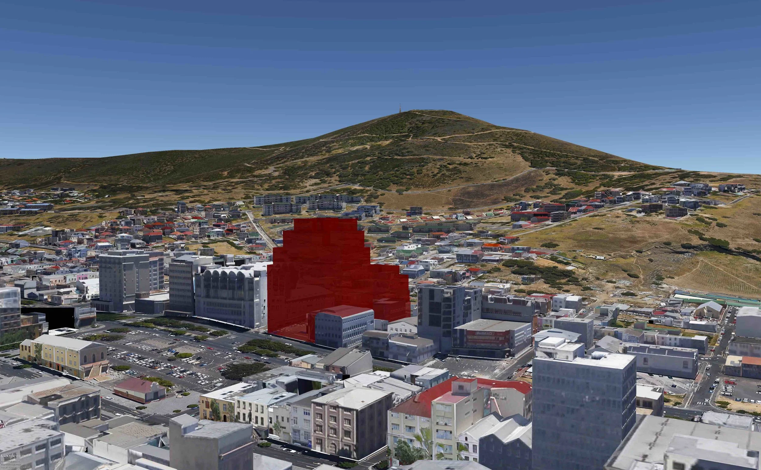
The proposed development is over the majority of a city block, that is bounded by Buitengracht and Van Riebeeck Square on the South-East, Rose Street on the North-West, Shortmarket St on the North-East, and Longmarket Street on the South-West. It is indicated in red in the Google Earth Aerial photo below. The reason that it isn’t the whole block is that the person who owns the buildings inside the “step” has refused to sell to the developers, and is strongly opposed to the development.

2. WHAT IS BEING PROPOSED?
A 19-storey mixed-use building with 249 residential units and 324 parking bays accessed off Shortmarket Street and with approx. 5000m2 of commercial and retail on the ground floors. This proposal is 60m high on Buitengracht St and 38m high on Rose Street. It is MUCH LARGER AND HIGHER THAN ANYTHING ELSE IN THE AREA, with the exception of the unattractive and out-of-place Chris Barnard Memorial Hospital.
The following images show the proposed building from a range of different positions and perspectives:

Bird’s Eye View Photo-montage utilizing Google Earth and SketchUp, showing the proposed building (in white in the centre) in its setting when looking towards the east from above Chiappini and Church Streets (courtesy Wynand Tromp of Rick Brown Architects)

Bird’s Eye View Photo-montage utilizing Google Earth and SketchUp, showing the proposed building (in white towards the right) in its setting, with the Buitengracht, Heritage Square and Riebeeck Square in the centre. Note the 60m height of the City Park Hospital—the same height as the proposed building under review! (Courtesy Wynand Tromp of Rick Brown Architects)

Bird’s Eye View Photo-montage utilizing Google Earth and SketchUp, showing the proposed building (in white in the centre) in its setting, with Riebeeck Square and Heritage Square in the foreground (to the left and right, respectively) (courtesy Wynand Tromp of Rick Brown Architect
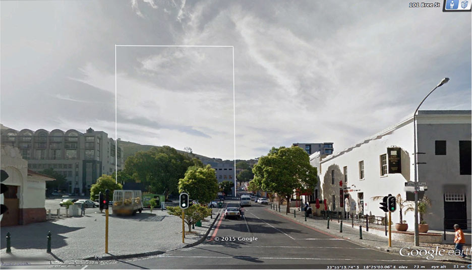
Street-level view from the eastern corner of Riebeeck Square (101 Bree Street) looking westwards towards the site of the proposed ±20 storey building development (the approximate outline-massing of the elevation of the building is shown in white outline, without the small proposed set- backs from about 38m up) with the ±10 storey Studios Building appearing to the left and the 2-3 storey Heritage Square to the right: (courtesy GoogleEarth Streetview).
3. WHAT WILL THE PRACTICAL IMPACTS BE ON MY PROPERTY AND ON THE SURROUNDING AREA?
OVERSHADOWING
The oversized scale of the proposal will lead to overshadowing of the surrounding streets and buildings which will change over the year, depending on the season and the angle of the sun. Overshadowing has two negative effects. The first is that it creates dark and unpleasant streetscapes, as well as casting shadows over surrounding buildings and affecting the quality of light and warmth that comes into the buildings. By reducing the amount of sun that reaches the roofs of the surrounding buildings, it also reduces residents’ capacity to generate solar energy for both solar water heating and electricity and reduces residents’ capacity to have a garden (both for food and beauty). These will become increasingly important issues in the future, as electricity and food get more and more expensive, and as the world moves into a future with less available resources.

June Shadow at different times of the day that would be cast by the proposed building (courtesy Wynand Tromp of Rick Brown Architects)
WIND EFFECT
Tall buildings create increased turbulence at the streetscape due to the barrier they place in the path of the wind. In this way, they make the streetscape around them unpleasant. They also impact the buildings surrounding them. This is particularly severe when the building is facing the prevailing winds at 90 degrees. The proposed development is at exactly 90 degrees to both the prevailing summer wind – the South Easter and the prevailing winter wind – the North Wester.

Courtesy BBC “The problem with the skyscraper wind effect http://www.bbc.com/news/magazine-33426889
PRIVACY
The building is designed to step down towards Rose Street in a series of terraces and balconies. All North-West facing windows and balconies look directly into the bowl of the Bo-Kaap and will compromise people’s privacy, starting in Rose Street and going as high up as Dawes Street, and possibly beyond. In addition to this, Bo-Kaap residents and visitors will feel like they are in a fish-bowl when walking around the streets - being watched over by the residents of the proposed development.
PARKING AND TRAFFIC
The proposed development includes 249 dwelling units, and 324 parking bays. The parking garage (a 3-storey basement excavation) is accessed off Shortmarket St, with the traffic coming into Rose Street, as Shortmarket is a one-way going up. Rose Street is already very congested at rush hours as it used as a rat-run by passing commuters, so this will severely increase the problem. Further, the ground floors are designed as businesses and shops and all these will require parking, some of which will be on-street. There is already a severe parking problem in the Bo-Kaap with non-residents clogging up parking outside residents’ homes during the day, and this will become even more severe if the proposed development goes ahead. The amount of proposed parking bays and dwelling units is completely inappropriate for the area.
VISUAL CONNECTIONS
The proposed development will further block out views between the Bo-Kaap and the City. These views and connections are part of what makes Cape Town so special, and are historic in nature. The strip of city blocks between Rose and Buitengracht, Wale and Strand is a very important strip of city that used to be part of the Bo-Kaap and was insensitively rezoned during the Apartheid era to create a barrier between the Bo-Kaap and the City. The proposed development will exacerbate the barrier effect, increasing the ongoing “us and them” trend. The blocking of historic view lines is also contrary to declared CoCT policy.
STRUCTURAL DAMAGE
The development proposes a 3-storey deep basement parking garage. This is completely over-scaled and has the potential to cause severe damage to the surrounding buildings during construction. Many of the surrounding buildings are made of sun-dried bricks with small or no foundations and due to the nature of underlying rock (Malmesbury Shale) in the area, could very well be damaged when the basement is excavated. The proposed excavations are far deeper and more extensive than those that were undertaken for the construction of the Hilton Hotel, which caused severe cracking to some old structures.
4. WHAT ARE THE POTENTIAL SOCIAL, CULTURAL AND ECONOMIC IMPACTS?
GENTRIFICATION
In addition to the fish-bowl effect described above in the “PRIVACY” section, there are other negative social, cultural and economic impacts. The proposal includes 249 dwelling units, a very high number of new units relative to the social carrying capacity of the area. The target market for these is middle to upper income people. This is not the kind of housing that Cape Town needs more of, rather Cape Town desperately needs affordable, social housing. By allowing more of this kind of exclusive development at the scale and numbers proposed, the CoCT will increase the high levels of inequality that exist in our city and exacerbate pressing social issues. Further, this kind of development tends to attract speculative investment where people buy the units to rent out, and in this way have no personal investment in the area – people with no interest in or relationship to the unique cultural, social and religious qualities of the area that make the Bo-Kaap so special. The sheer volume of numbers of proposed new dwelling units will thus exacerbate the already concerning gentrification trend in the Bo-Kaap.
DENSIFICATION
The developers argue that their proposed development is in line with the CoCT’s Densification Policy. However, this is incorrect. Densification is intended to make the city more equitable and to promote equal access to services, transportation and amenities, particularly for Cape Town’s less affluent citizens. As per the City of Cape Town’s policy, densification should not be promoted everywhere indiscriminately. It should be promoted only where it is contextually suitable and should follow the urban restructuring policy of densification along development corridors, and not densification that exacerbates the current situation of a concentrated city centre. As indicated in the diagrams below, densification doesn’t only mean tall buildings. It should rather take the form of terraces or perimeter blocks (both of which are far more appropriate to the Bo-Kaap). “Tall buildings can destroy elements that give Cape Town its special and unique identity.” – CoCT Tall Building Policy
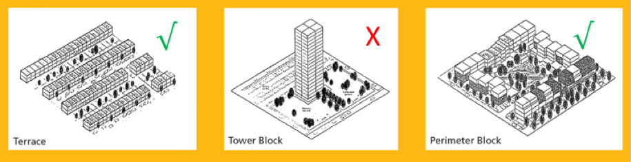
The Same Density Depicted in Different Building Forms. (CoCT, Densification Policy, 2012: 6)
TOURISM AND OTHER ECONOMIC DRIVERS
Cape Town – the “Mother City” – is loved for its unique qualities – particularly the intersection of natural and historical elements in the City Bowl. The proposed development does not take into account the heritage aspects of the area, rather proposing an overscaled apartment tower-block that is more in keeping with the Miami beachfront as opposed to one of Cape Town’s oldest public spaces – Van Riebeeck Square. If this building goes ahead as planned it will undermine the economic benefits derived from foreign investment, tourism and the film industry, all important players in Cape Town’s economy.
INCREASED RATES
Bo-kaap includes in the region of 800 households. The proposed development would mean an additional 249 households. If it goes ahead then the tower block alone would represent approximately 25% of the Bo-kaap households! This will contribute to the gentrification issue described above, and most concerningly will probably result in the rates of the whole of the Bo-kaap being increased dramatically and thus making it even more unaffordable for families who have lived in the area for generations.
5. IS IT INCONSISTENT WITH CITY OF CAPE TOWN POLICY?
Yes. The proposed development is inconsistent with a number of City of Cape Town Policies. All of these are used by the developer to argue for why the proposal is in line with CoCT policy, however, it is clear that the developer has either been extremely selective when applying policy guidelines thereby obfuscating by omission, or else has misread or misunderstood key policies. The extent of this is thoroughly outlined in Prof. Fabio Todeschini’s report.
The policies that it is inconsistent with include the:
- CoCT SPATIAL DEVELOPMENT FRAMEWORK
- CoCT TALL BUILDINGS POLICY
- CoCT DENSIFICATION POLICY
- District Spatial Development Framework
- Central City Draft Development Strategy proposals (this has not been adopted as CoCT policy)
6. WHAT ARE THE KEY HERITAGE ISSUES (INCLUDING THE HEIGHT ISSUES)?
HERITAGE AREA
The site of the proposed development question is flanked to the north-west by the historic Bo- Kaap and to the south-east by Van Riebeek Square—both previously proclaimed National Monuments and now Provincial Heritage Sites (PHS).2 To the immediate east of the site is ‘Heritage Square’: the entire city block retained by city policy. Accordingly, the site is within the Heritage Protection Overlay Zone HPO/2/3 (previously the Central City Conservation Area) where the aims of heritage resources management, via such overlay zoning and related instruments, are the retention of the character occasioned by the heritage, only permissive of new development to the extent and to the degree that such new development does not intrude on, or do damage to, the very significant surviving heritage and resulting townscape.
PROPOSED HEIGHTS NOT “AS OF RIGHT”
Because of the HPO/2/3, the 38m and 60m proposed heights of the development are not ‘as of right’. Yet the development proposals not only assume that that they are ‘as of right’, they require further set-back, building-line and other departures that would have the effect of enlarging the overall, bloated building envelope even further.
CITY’S OMISSION IN NOT REQUESTING A HERITAGE ASSESSMENT
Despite, the above, the CoCT officials did not request a Heritage Impact Assessment from an accredited professional. This is either a deliberate oversight privileging the developer and acting against the public interest, or a genuine case of the officials not adequately applying their minds to the impacts of the proposed development.
PRECEDENT
Should the development go ahead then it will set a highly problematic precedent and open the floodgates for even more insensitive and inappropriate development on the strip of city blocks between Rose and Buitengracht, Van Riebeeck Square and the Bo-Kaap.
7. HOW HAVE THE CITY OF CAPE TOWN OFFICIALS RESPONDED TO ENGAGING WITH OBJECTORS?
Prof. Fabio Todeschini, acting on behalf of the Bo-Kaap Civic and Ratepayers Association and most importantly, in the public interest, wrote to the CoCT Head of Spatial Planning and other relevant officials in December 2015 requesting that they meet with him to discuss the proposal, given how large it is, and that it is situated in such an important historic and culturally sensitive area. They refused to meet with him, suggesting that they would be “compromising the application process”, this despite the City having met with the developers on a number of occasions. This conduct points to serious procedural problems and is patently unfair. It appears that the City could be privileging developers over citizens, and this is cause for great concern.